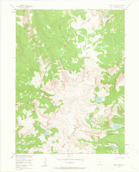
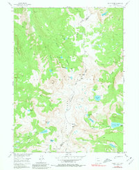
1955 Map of Mount Ethel
USGS Topo · Published 1963About this map
The Continental Divide winds across this section of the Park Range, marking the high alpine separation between Jackson and Routt counties. In the mid-1950s, this portion of the Routt National Forest was defined by its high peaks and an intricate network of glacial lakes and headwaters. Prominent summits like Mount Ethel and Lost Ranger Peak tower over the landscape, while the topography reveals the drainage patterns of the South Fork Elk River and Mad Creek. The presence of established paths such as the Rainbow Trail and Ranger Trail suggests a landscape managed for both timber and recreation during the post-war era. For researchers, the map provides precise locations for remote water bodies like Lake of the Crags and Pristine Lake, reflecting the hydrographic detail captured by the Department of the Interior during its development program for the Missouri River Basin.
Find a feature on this map
41 named features on this map. Tap any name to fly to it.
Don’t see what you’re looking for? This feature index may not catch every label — zoom into the map to look around manually.
Map Details
Editions of this 1955 Mount Ethel Map
6 editions found
Other maps of this area

1911 · Hahns Peak
USGS Topo · 1:125,000

1913 · Hahns Peak
USGS Topo · 1:125,000

1954 · Craig
USGS Topo · 1:250,000

1955 · Buffalo Pass
USGS Topo · 1:24,000

1955 · Mount Zirkel
USGS Topo · 1:24,000

1955 · Pitchpine Mountain
USGS Topo · 1:24,000

1955 · Mount Ethel
USGS Topo · 1:24,000

1955 · Teal Lake
USGS Topo · 1:24,000

1955 · Mount Ethel
USGS Topo · 1:62,500
1956 · Boettcher Lake
USGS Topo · 1:24,000