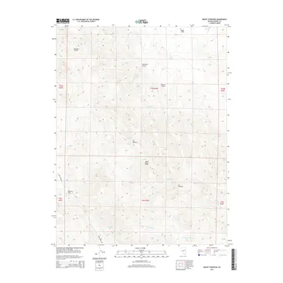
2014 Map of Mount Ferguson
USGS Topo · Published 2014About this map
Mt Ferguson dominates the southern landscape of this Mineral County quadrangle, situated within the high terrain of the Gabbs Valley Range. This area of Nevada is defined by its complex drainage systems and life-sustaining water sources, with numerous named springs appearing throughout the range, including Paint Rock Spring and McGregor Spring. The presence of Rhyolite Pass suggests the volcanic geological history of the region, while labels like Petrified Wash and Upper Petrified Spring point to significant fossilized remains in the local strata. The mapping captures a network of canyons and washes, such as Boundary Canyon and Paint Rock Canyon, that funnel toward the Gabbs Valley to the north. Only a few modern traces of transit are noted, specifically Rabbit Springs Rd, highlighting the high-elevation isolation of these peaks and basins.
Find a feature on this map
27 named features on this map. Tap any name to fly to it.
Don’t see what you’re looking for? This feature index may not catch every label — zoom into the map to look around manually.
Map Details
Editions of this 2014 Mount Ferguson Map
This is the sole edition of this map. No revisions or reprints were ever made.
Other maps of this area

1909 · Hawthorne
USGS Topo · 1:250,000

1911 · Hawthorne
USGS Topo · 1:250,000

1915 · Hawthorne
USGS Topo · 1:250,000

1948 · Walker Lake
USGS Topo · 1:250,000

1957 · Walker Lake
USGS Topo · 1:250,000

1962 · Walker Lake
USGS Topo · 1:250,000

1964 · Walker Lake
USGS Topo · 1:250,000
1979 · Indian Head Peak
USGS Topo · 1:24,000
1979 · Ramsey Spring
USGS Topo · 1:24,000
1979 · Win Wan Flat
USGS Topo · 1:24,000