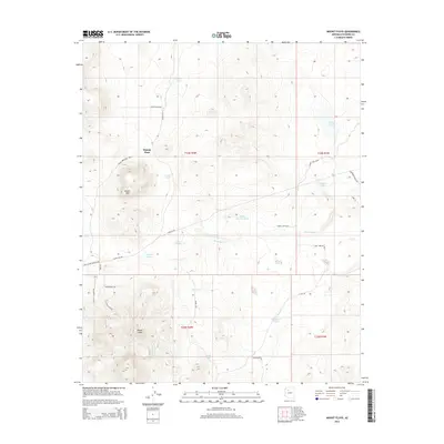
2014 Map of Mount Floyd
USGS Topo · Published 2014About this map
Mount Floyd dominates the southern reaches of this Coconino County terrain, standing as a prominent landmark above the surrounding high plateau. The landscape is defined by a sophisticated network of water management features essential for ranching and resource extraction, including Smith Tanks, Floyd Tank, and the Mud Tank. The presence of the Coal Slurry Pipeline Rd and Slurry Line Rd indicates the industrial infrastructure crossing this region, while local ranching life is centered around Bishop Place in the northwest. Unique road names like Elvis Presley Blvd, Delicate Thunder RD, and Olivas Alone Rd suggest a more recent layer of human naming conventions superimposed over traditional topographic features like Round Mtn and the seasonal flows of Partridge Cr.
Find a feature on this map
35 named features on this map. Tap any name to fly to it.
Don’t see what you’re looking for? This feature index may not catch every label — zoom into the map to look around manually.
Map Details
Editions of this 2014 Mount Floyd Map
This is the sole edition of this map. No revisions or reprints were ever made.
Other maps of this area

1886 · Chino
USGS Topo · 1:250,000

1891 · Chino
USGS Topo · 1:250,000

1948 · Williams
USGS Topo · 1:250,000

1954 · Williams
USGS Topo · 1:250,000

1956 · Williams
USGS Topo · 1:250,000

1960 · Williams
USGS Topo · 1:250,000

1961 · Williams
USGS Topo · 1:250,000
1973 · Mount Floyd
USGS Topo · 1:24,000
1973 · Eagle Nest Mtn
USGS Topo · 1:24,000
1973 · Horse Trap Mesa
USGS Topo · 1:24,000