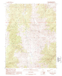
1989 Map of Mount Grant
USGS Topo · Published 1989About this map
Mount Grant anchors this section of the high Wassuk Range in Mineral County, overlooking a landscape defined by military operations and extensive mineral exploration. Large swaths of the eastern slopes are occupied by the Hawthorne Army Ammunition Plant, with its complex network of access roads and infrastructure reaching toward Dutch Creek and Rose Creek. The surrounding terrain is heavily marked by industrial history, with numerous Prospects, an Adit, and multiple Mine Shaft locations scattered across the ridges and canyons.
Find a feature on this map
23 named features on this map. Tap any name to fly to it.
Don’t see what you’re looking for? This feature index may not catch every label — zoom into the map to look around manually.
Map Details
Editions of this 1989 Mount Grant Map
2 editions found
Other maps of this area

1909 · Hawthorne
USGS Topo · 1:250,000

1911 · Hawthorne
USGS Topo · 1:250,000

1915 · Hawthorne
USGS Topo · 1:250,000

1948 · Walker Lake
USGS Topo · 1:250,000

1955 · Powell Mtn
USGS Topo · 1:62,500

1955 · Hawthorne
USGS Topo · 1:62,500

1956 · Mt. Grant
USGS Topo · 1:62,500

1956 · Aurora
USGS Topo · 1:62,500

1957 · Walker Lake
USGS Topo · 1:250,000

1962 · Walker Lake
USGS Topo · 1:250,000