1964 Map of Mount Guyot
USGS Topo · Published 1966About this map
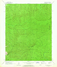
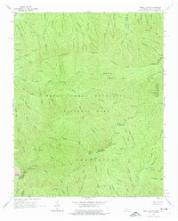
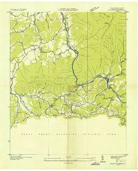
Great Smoky Mountains National Park dominates this mid-1960s survey, illustrating the high-elevation wilderness along the border of Tennessee and North Carolina. The Appalachian Trail snakes along the primary drainage divide, passing through landmarks like Mount Guyot, Tricorner Knob, and the distinctive rock profile of Charles Bunion. This map provides a detailed view of the region's complex hydrology, with the Middle Prong Little Pigeon River and its numerous tributaries such as Ramsey Prong and Texas Creek carving deep into the southern Appalachian massif. Cultural imprints within the park are limited to essential hiking infrastructure, including a Lookout Tower near the Pinnacle and various backcountry shelters. The topography is defined by massive ridges like Dashoga Ridge and Hughes Ridge, which separate the headwaters of the Raven Fork from the northern-flowing streams that eventually reach the Tennessee Valley.
Find a feature on this map
93 named features on this map. Tap any name to fly to it.
Don’t see what you’re looking for? This feature index may not catch every label — zoom into the map to look around manually.
Map Details
Editions of this 1964 Mount Guyot Map
2 editions found
Other maps of this area

1893 · Mt Guyot
USGS Topo · 1:125,000

1912 · Mt Guyot
USGS Topo · 1:125,000

1935 · Newport
USGS Topo · 1:48,000
1935 · Hartford
USGS Topo · 1:24,000

1935 · English Mountain
USGS Topo · 1:48,000

1935 · Jones Cove
USGS Topo · 1:24,000

1935 · Richardson Cove
USGS Topo · 1:24,000

1936 · Bunches Bald
USGS Topo · 1:24,000

1936 · Ravensford
USGS Topo · 1:24,000

1936 · Cartertown
USGS Topo · 1:24,000