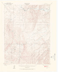
1924 Map of Mount Harris
USGS Topo · Published 1964About this map
The Yampa River and Bear River corridor defines this portion of Routt County, where the Denver and Rio Grande Western railroad tracks follow the river's winding path through the northern landscape. In 1924, coal mining and ranching infrastructure shaped the local geography, anchoring small communities like Mount Harris, Milner, and Coal View. The distribution of rural education is particularly evident here, with a network of local institutions including Pleasant View School, Windy Point School, and Foidel School serving families scattered across the high country.
Find a feature on this map
41 named features on this map. Tap any name to fly to it.
Don’t see what you’re looking for? This feature index may not catch every label — zoom into the map to look around manually.
Map Details
Editions of this 1924 Mount Harris Map
4 editions found
Other maps of this area

1911 · Hahns Peak
USGS Topo · 1:125,000

1913 · Hahns Peak
USGS Topo · 1:125,000

1916 · Daton Peak
USGS Topo · 1:62,500

1920 · Daton Peak
USGS Topo · 1:62,500

1923 · Elkhead Creek
USGS Topo · 1:62,500

1923 · Pilot Knob
USGS Topo · 1:62,500

1924 · Elkhead Creek
USGS Topo · 1:62,500

1924 · Mt. Harris
USGS Topo · 1:48,000

1925 · Pilot Knob
USGS Topo · 1:62,500

1926 · Mount Harris
USGS Topo · 1:62,500