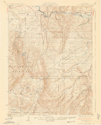
1926 Map of Mount Harris
USGS Topo · Published 1926About this map
Hayden and the mining-centric settlement of Mount Harris anchor the northern landscape of this 1920s survey, where the Yampa River serves as the primary corridor for commerce and transport. The Denver and Salt Lake RR winds along the riverbank, connecting coal-reliant outposts like Coal View and McGregor to the broader regional economy. Away from the rail lines, the terrain rises into the Williams Fork Mountains and the high plateaus of Twentymile Park.
Find a feature on this map
42 named features on this map. Tap any name to fly to it.
Don’t see what you’re looking for? This feature index may not catch every label — zoom into the map to look around manually.
Map Details
Editions of this 1926 Mount Harris Map
2 editions found
Other maps of this area

1911 · Hahns Peak
USGS Topo · 1:125,000

1913 · Hahns Peak
USGS Topo · 1:125,000

1916 · Daton Peak
USGS Topo · 1:62,500

1920 · Daton Peak
USGS Topo · 1:62,500

1923 · Elkhead Creek
USGS Topo · 1:62,500

1923 · Pilot Knob
USGS Topo · 1:62,500

1924 · Elkhead Creek
USGS Topo · 1:62,500

1924 · Mt. Harris
USGS Topo · 1:48,000

1925 · Pilot Knob
USGS Topo · 1:62,500

1926 · Mount Harris
USGS Topo · 1:62,500