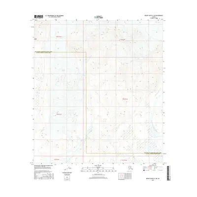
2016 Map of Mount Hayes A-3 NE
USGS Topo · Published 2016About this map
The glacial landscapes of the Alaska Range dominate this interior region of Alaska, where ice and meltwater carve deep paths through the high terrain. The massive Gakona Glacier feeds directly into the headwaters of the Gakona River, which flows southwest toward its eventual confluence. To the east, the drainage basin is split by the West Fork Chistochina River and its upper reaches, labeled here as the W Fork Chistochina River. This map also documents the administrative divide where the Southeast Fairbanks and Valdez-Cordova Census Areas meet. The lack of roads or settlements highlights the isolation of this high-latitude wilderness, where the geography is defined entirely by moving ice and seasonal river systems.
Find a feature on this map
12 named features on this map. Tap any name to fly to it.
Don’t see what you’re looking for? This feature index may not catch every label — zoom into the map to look around manually.
Map Details
Editions of this 2016 Mount Hayes A-3 NE Map
This is the sole edition of this map. No revisions or reprints were ever made.
Other maps of this area

1950 · Mount Hayes
USGS Topo · 1:250,000

1950 · Mount Hayes A-3
USGS Topo · 1:63,360

1951 · Mount Hayes
USGS Topo · 1:250,000

1952 · Mount Hayes A-3
USGS Topo · 1:63,360
1954 · Mount Hayes A-3
USGS Topo · 1:63,360
1955 · Mount Hayes A-2
USGS Topo · 1:63,360

1955 · Mount Hayes B-3
USGS Topo · 1:63,360

1955 · Mount Hayes B-2
USGS Topo · 1:63,360

1955 · Mount Hayes
USGS Topo · 1:250,000
2016 · Mount Hayes A-3 SE
USGS Topo · 1:25,000