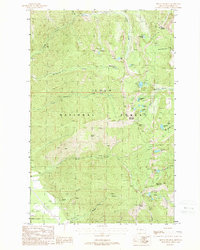
1988 Map of Mount Headley
USGS Topo · Published 1988About this map
Lolo National Forest dominates this high-country landscape in northwestern Montana, defined by a network of ridges and glacial lakes. Centered on the peaks of Mount Headley, Cube Iron Mountain, and Mount Silcox, the topography is carved by drainages like Graves Creek and Squaw Creek. The map reveals a land utilized for both resource extraction and wilderness transit, where a Gravel Pit and modern Transmission Lines near Maier contrast with the extensive system of Pack Trails that provide the only access to remote waters such as Arrowhead Lake, Carbine Lake, and the Goat Lakes.
Find a feature on this map
37 named features on this map. Tap any name to fly to it.
Don’t see what you’re looking for? This feature index may not catch every label — zoom into the map to look around manually.
Map Details
Editions of this 1988 Mount Headley Map
This is the sole edition of this map. No revisions or reprints were ever made.
Other maps of this area

1937 · Thompson Falls
USGS Topo · 1:125,000

1937 · Thompson Falls
USGS Topo · 1:62,500

1956 · Wallace
USGS Topo · 1:250,000

1957 · Thompson Falls
USGS Topo · 1:62,500

1960 · Wallace
USGS Topo · 1:250,000

1964 · Eddy Mountain
USGS Topo · 1:24,000
1964 · Priscilla Peak
USGS Topo · 1:24,000

1966 · Vermilion Peak
USGS Topo · 1:24,000
1966 · Seven Point Mountain
USGS Topo · 1:24,000
1966 · Fishtrap Lake
USGS Topo · 1:24,000