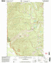
1999 Map of Mount Headley
USGS Topo · Published 2003About this map
Lolo National Forest dominates this high-elevation region of Sanders County, defined by several prominent summits including Mount Headley and Mount Silcox. The topography is characterized by a dense network of mountain streams and glacial lakes, with Graves Creek and Winnemuck Creek draining the steep slopes. The eastern half of the map features a notable cluster of alpine water bodies known as Four Lakes, alongside specifically named basins like Duckhead Lake and Frog Lake. Human activity is sparse and largely relegated to the lower elevations near Weber Gulch, where a Gravel Pit and a Communication Tower on a southern ridge mark the intersection of modern infrastructure with the wilderness. The detailed survey of Cube Iron Mountain and surrounding peaks provides an intricate record of the backcountry trails and natural landmarks that define this portion of the Cabinet Mountains.
Find a feature on this map
38 named features on this map. Tap any name to fly to it.
Don’t see what you’re looking for? This feature index may not catch every label — zoom into the map to look around manually.
Map Details
Editions of this 1999 Mount Headley Map
This is the sole edition of this map. No revisions or reprints were ever made.
Other maps of this area

1937 · Thompson Falls
USGS Topo · 1:125,000

1937 · Thompson Falls
USGS Topo · 1:62,500

1956 · Wallace
USGS Topo · 1:250,000

1957 · Thompson Falls
USGS Topo · 1:62,500

1960 · Wallace
USGS Topo · 1:250,000

1964 · Eddy Mountain
USGS Topo · 1:24,000
1964 · Priscilla Peak
USGS Topo · 1:24,000

1966 · Vermilion Peak
USGS Topo · 1:24,000
1966 · Seven Point Mountain
USGS Topo · 1:24,000
1966 · Fishtrap Lake
USGS Topo · 1:24,000