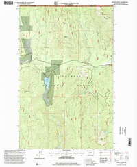
1997 Map of Mount Henry
USGS Topo · Published 2000About this map
The Canada-United States border defines the northern edge of this high-country survey in the Kootenai National Forest. The landscape is dominated by the drainage systems of the Yaak River and its East Fork, where the Boyd Hill Cemetery provides a rare localized historical marker in a region primarily shaped by timber and fire management. High peaks such as Caribou Mountain and Grubstake Mountain rise above the watershed, which includes remote water bodies like Okaga Lake and the Fish Lakes.
Find a feature on this map
27 named features on this map. Tap any name to fly to it.
Don’t see what you’re looking for? This feature index may not catch every label — zoom into the map to look around manually.
Map Details
Editions of this 1997 Mount Henry Map
This is the sole edition of this map. No revisions or reprints were ever made.
Other maps of this area

1957 · Kalispell
USGS Topo · 1:250,000

1960 · Kalispell
USGS Topo · 1:250,000

1961 · Kalispell
USGS Topo · 1:250,000

1963 · Yaak
USGS Topo · 1:24,000

1963 · Robinson Mountain
USGS Topo · 1:24,000

1963 · Boulder Lakes
USGS Topo · 1:24,000

1963 · Bonnet Top
USGS Topo · 1:24,000

1963 · Mount Henry
USGS Topo · 1:24,000

1963 · Lost Horse Mountain
USGS Topo · 1:24,000

1979 · Yaak River
USGS Topo · 1:100,000