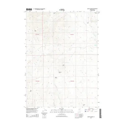
2015 Map of Mount Ichabod
USGS Topo · Published 2015About this map
Mount Ichabod and the Fox Creek Range dominate this high-desert landscape in northeastern Nevada, where the drainage systems of the Bruneau River and E Fork Beaver Cr define the high country. The map documents a rugged cattle-country geography marked by remote water sources like the Charleston Reservoir and Dry Lake Reservoir, which are vital in this arid environment. Ranching history is implied by the presence of named grazing areas such as Evans Flat and the high-altitude Jenkins Meadows.
Find a feature on this map
25 named features on this map. Tap any name to fly to it.
Don’t see what you’re looking for? This feature index may not catch every label — zoom into the map to look around manually.
Map Details
Editions of this 2015 Mount Ichabod Map
This is the sole edition of this map. No revisions or reprints were ever made.
Other maps of this area

1935 · Charleston
USGS Topo · 1:48,000

1942 · Mt. Velma
USGS Topo · 1:62,500

1955 · Wells
USGS Topo · 1:250,000

1958 · Wells
USGS Topo · 1:250,000

1961 · Wells
USGS Topo · 1:250,000

1967 · Stag Mountain
USGS Topo · 1:24,000

1968 · Charleston Reservoir
USGS Topo · 1:24,000
1968 · Marys River Basin NW
USGS Topo · 1:24,000

1971 · Double Mtn
USGS Topo · 1:24,000

1971 · Devils Armchair
USGS Topo · 1:24,000