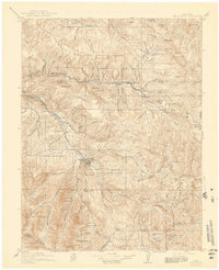
1911 Map of Mount Jackson
USGS Topo · Published 1941About this map
Aspen serves as the focal point of this 1911 survey, situated at the confluence of the Roaring Fork and Castle Creek. The landscape is defined by the high-altitude mining and ranching economy of the early twentieth century, with the Little Annie Mine and Montezuma Mine marking the extraction history of the surrounding peaks. Transportation is dominated by the competing paths of the Colorado Midland RR and the Denver and Rio Grande RR, which navigated the formidable terrain to reach mountain outposts. The map documents numerous small settlements and stops like Ashcroft, Thomasville, and Ruedi, many of which were tied to the railroads or timber and mining interests. To the east, Independence Pass provides a vital crossing through the Williams Mountains, while water features like Loch Ivanhoe and the Devils Punchbowl illustrate the complex hydrology of the Continental Divide.
Find a feature on this map
129 named features on this map. Tap any name to fly to it.
Don’t see what you’re looking for? This feature index may not catch every label — zoom into the map to look around manually.
Map Details
Editions of this 1911 Mount Jackson Map
3 editions found

Other maps of this area

1888 · Crested Butte
USGS Topo · 1:62,500

1888 · Anthracite
USGS Topo · 1:62,500

1889 · Crested Butte
USGS Topo · 1:62,500

1889 · Anthracite
USGS Topo · 1:62,500

1889 · Leadville
USGS Topo · 1:125,000

1891 · Leadville
USGS Topo · 1:125,000

1893 · Anthracite
USGS Topo · 1:62,500

1893 · Crested Butte
USGS Topo · 1:62,500

1893 · Aspen
USGS Topo · 1:62,500

1894 · Anthracite
USGS Topo · 1:62,500