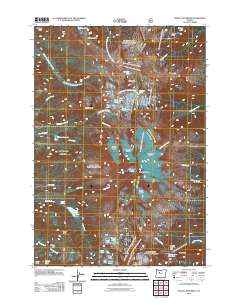
2011 Map of Mount Jefferson
USGS Topo · Published 2011About this map
Mount Jefferson dominates this high-altitude landscape in the central Oregon Cascades, where a massive glacial system feeds the headwaters of several major drainages. This 2011 survey documents the ice-bound topography of Russell Glacier, Jefferson Park Glacier, and Whitewater Glacier, alongside the Milk Creek Glacier and Waldo Glacier. These frozen fields give way to the meadows of Jefferson Park and Hole-in-the-Wall Park, illustrating the classic volcanic alpine environment.
Find a feature on this map
50 named features on this map. Tap any name to fly to it.
Don’t see what you’re looking for? This feature index may not catch every label — zoom into the map to look around manually.
Map Details
Editions of this 2011 Mount Jefferson Map
This is the sole edition of this map. No revisions or reprints were ever made.
Other maps of this area

1927 · Mt. Jefferson
USGS Topo · 1:125,000

1930 · Mt. Jefferson
USGS Topo · 1:125,000

1955 · Bend
USGS Topo · 1:250,000

1957 · Bend
USGS Topo · 1:250,000

1958 · Bend
USGS Topo · 1:250,000

1961 · Whitewater River
USGS Topo · 1:62,500

1961 · Fort Butte
USGS Topo · 1:62,500
1961 · Mt. Jefferson
USGS Topo · 1:62,500
1961 · Breitenbush Hot Springs
USGS Topo · 1:62,500
1983 · Madras
USGS Topo · 1:100,000