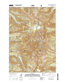
2014 Map of Mount Jefferson
USGS Topo · Published 2014About this map
Mount Jefferson stands as the towering centerpiece of this high-altitude landscape, where the borders of Marion, Jefferson, and Linn counties converge. The terrain is defined by its glacial systems, including the Russell Glacier, Whitewater Glacier, and Waldo Glacier, which feed a network of alpine waterways such as the Whitewater River and Milk Creek. This 2014 survey documents the complex drainage and topography of the central Cascades, where the Pacific Crest National Scenic Trail winds through the high country past landmarks like Jefferson Park and Cathedral Rocks. The map reveals a land shaped by ice and elevation, punctuated by features like The Table and Lizard Ridge. Lower elevations offer a shift in character at Grizzly Flat and near the secluded waters of Pamela Lake, providing a detailed record of this protected wilderness across the Mount Hood National Forest and Willamette National Forest.
Find a feature on this map
56 named features on this map. Tap any name to fly to it.
Don’t see what you’re looking for? This feature index may not catch every label — zoom into the map to look around manually.
Map Details
Editions of this 2014 Mount Jefferson Map
This is the sole edition of this map. No revisions or reprints were ever made.
Other maps of this area

1927 · Mt. Jefferson
USGS Topo · 1:125,000

1930 · Mt. Jefferson
USGS Topo · 1:125,000

1955 · Bend
USGS Topo · 1:250,000

1957 · Bend
USGS Topo · 1:250,000

1958 · Bend
USGS Topo · 1:250,000

1961 · Whitewater River
USGS Topo · 1:62,500

1961 · Fort Butte
USGS Topo · 1:62,500
1961 · Mt. Jefferson
USGS Topo · 1:62,500
1961 · Breitenbush Hot Springs
USGS Topo · 1:62,500
1983 · Madras
USGS Topo · 1:100,000