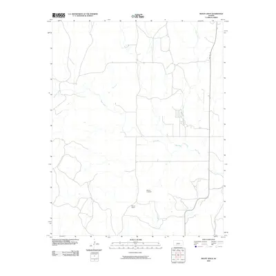
2009 Map of Mount Jesus
USGS Topo · Published 2009About this map
Mount Jesus and Mount Lookout rise above the high plains of Clark County, defining the local topography in this late-aughts survey. The landscape is carved by a complex network of seasonal drainages, with the meandering path of Bluff Creek serving as a central hydrologic feature as it receives tributaries like Fish Creek and Cat Creek. This map illustrates the intersection of natural landmarks and modern infrastructure, where State Hwy 34 cuts north-south through the eastern territory, providing the primary arterial access to these prominent hills. Researchers can trace the dendritic drainage patterns of Granger Creek and Hackberry Creek, which reflect the erosional forces that have shaped this portion of Kansas. The arrangement of section-line roads throughout the quadrangle highlights the enduring influence of the Public Land Survey System on the regional layout.
Find a feature on this map
9 named features on this map. Tap any name to fly to it.
Don’t see what you’re looking for? This feature index may not catch every label — zoom into the map to look around manually.
Map Details
Editions of this 2009 Mount Jesus Map
This is the sole edition of this map. No revisions or reprints were ever made.
Other maps of this area

1894 · Sitka
USGS Topo · 1:62,500

1896 · Ashland
USGS Topo · 1:125,000

1955 · Pratt
USGS Topo · 1:250,000

1959 · Pratt
USGS Topo · 1:250,000
1972 · Ashland
USGS Topo · 1:24,000

1979 · Sitka
USGS Topo · 1:24,000

1979 · Bloom SE
USGS Topo · 1:24,000

1979 · Sugarloaf
USGS Topo · 1:24,000

1979 · Turkey Creek
USGS Topo · 1:24,000
1979 · Simmons Creek
USGS Topo · 1:24,000