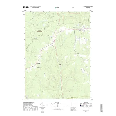
2019 Map of Mount Jewett
USGS Topo · Published 2019About this map
Mount Jewett and the surrounding high country of the Allegheny National Forest define this landscape along the border of McKean and Elk Counties. This 2019 survey captures a series of small, interconnected settlements like Lantz Corners, Kanesholm, and Coontown that are deeply tied to the regional topography. The drainage divide is evident here, with the W Br Clarion River flowing south and Kinzua Creek systems moving north. Genealogists will find notable detail at the Nebo Lutheran Chapel and Cem and Lebanon Lutheran Cem, while researchers of local geography can trace the modern road network against landmarks like Seven Mile Summit. The map documents a heavily forested region where recreation is prominent, noted by the extensive snowmobile trail system including Snowmobile Connector #20 (Snow) and Snowmobile Connector #17 (Snow).
Find a feature on this map
63 named features on this map. Tap any name to fly to it.
Don’t see what you’re looking for? This feature index may not catch every label — zoom into the map to look around manually.
Map Details
Editions of this 2019 Mount Jewett Map
This is the sole edition of this map. No revisions or reprints were ever made.
Other maps of this area

1924 · Bradford
USGS Topo · 1:62,500

1926 · Bradford
USGS Topo · 1:62,500

1934 · Kane
USGS Topo · 1:48,000

1935 · Mt. Jewett
USGS Topo · 1:48,000

1936 · Kinzua
USGS Topo · 1:48,000

1939 · Kane
USGS Topo · 1:62,500

1940 · Mt. Jewett
USGS Topo · 1:62,500

1941 · Kinzua
USGS Topo · 1:62,500

1941 · Bradford
USGS Topo · 1:62,500

1944 · Bradford
USGS Topo · 1:62,500
Featured Places
- Mount Jewett, PA
- Campbelltown, Hamlin Township
- Griffiths, Hamlin Township
- Cartwrights Crossing, Wetmore Township
- Jones Township, PA