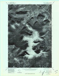
1978 Map of Mount Katahdin
USGS Topo · Published 1981About this map
Mount Katahdin dominates this orthophotoquad, which uses aerial photography taken in late October 1978 to reveal the stark, shadowed relief of the Maine wilderness. Unlike traditional topographic maps, this imagery provides a direct visual record of the high peaks, including Hamlin Peak and the distinctive formation known as The Owl. The drainage of Wassataquoik Stream carves through the northern portion of the quadrangle, flanked by Russell Mountain and Fort Mountain. The late-autumn sun creates deep shadows across the cirques and ridgelines, offering an unfiltered look at the geological structure of the terrain before the winter snows. This specific survey serves as a precise baseline for the landscape as it appeared in the late seventies, free from the interpretive layer of hand-drawn contour lines.
Find a feature on this map
7 named features on this map. Tap any name to fly to it.
Don’t see what you’re looking for? This feature index may not catch every label — zoom into the map to look around manually.
Map Details
Editions of this 1978 Mount Katahdin Map
This is the sole edition of this map. No revisions or reprints were ever made.
Other maps of this area

1927 · Katahdin
USGS Topo · 1:48,000

1930 · Katahdin
USGS Topo · 1:62,500

1949 · Katahdin
USGS Topo · 1:62,500

1953 · Telos Lake
USGS Topo · 1:62,500

1954 · Harrington Lake
USGS Topo · 1:62,500

1954 · Presque Isle
USGS Topo · 1:250,000

1954 · Millinocket
USGS Topo · 1:250,000

1955 · Traveler Mountain
USGS Topo · 1:62,500

1957 · Telos Lake
USGS Topo · 1:62,500

1958 · Presque Isle
USGS Topo · 1:250,000