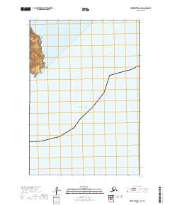
2019 Map of Mount Katmai A-1 SW
USGS Topo · Published 2019About this map
Katmai National Park defines the western edge of this coastal survey, where steep coastal cliffs meet the waters of the Pacific Ocean. This remote stretch of the Alaska Peninsula is characterized by the prominent landform of Cape Atushagvik, which guards the southern approach to Missak Bay. The terrain here is largely undeveloped, reflecting the protected status of the park and the maritime isolation of the Kodiak Island Borough shoreline. The map illustrates the sharp transition from the elevated peaks within the park boundaries down to the sea, providing a look at the natural topography before the onset of modern environmental changes in the 2010s.
Find a feature on this map
6 named features on this map. Tap any name to fly to it.
Don’t see what you’re looking for? This feature index may not catch every label — zoom into the map to look around manually.
Map Details
Editions of this 2019 Mount Katmai A-1 SW Map
This is the sole edition of this map. No revisions or reprints were ever made.
Other maps of this area

1948 · Mt Katmai
USGS Topo · 1:250,000

1951 · Mt Katmai
USGS Topo · 1:250,000

1951 · Karluk
USGS Topo · 1:250,000

1951 · Mount Katmai A-2
USGS Topo · 1:63,360
1951 · Mount Katmai A-1
USGS Topo · 1:63,360

1952 · Karluk
USGS Topo · 1:250,000

1964 · Mt. Katmai
USGS Topo · 1:250,000

1964 · Karluk
USGS Topo · 1:250,000
2019 · Mount Katmai A-2 NE
USGS Topo · 1:25,000
2019 · Mount Katmai A-2 SE
USGS Topo · 1:25,000