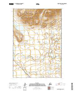
2019 Map of Mount Katmai A-6 NW
USGS Topo · Published 2019About this map
The remote Alaskan interior within the Lake and Peninsula Borough is defined here by the meeting of two major conservation areas, Katmai National Park and the Becharof National Wildlife Refuge. The landscape is a complex drainage system where Takayofo Creek winds through the southern reaches, complemented by the upper flows of Angle Creek and Contact Cr to the north. These waterways represent the intricate hydrology of the region before it reaches the larger coastal basins.
Find a feature on this map
11 named features on this map. Tap any name to fly to it.
Don’t see what you’re looking for? This feature index may not catch every label — zoom into the map to look around manually.
Map Details
Editions of this 2019 Mount Katmai A-6 NW Map
This is the sole edition of this map. No revisions or reprints were ever made.
Other maps of this area

1948 · Mt Katmai
USGS Topo · 1:250,000

1951 · Mt Katmai
USGS Topo · 1:250,000

1951 · Mount Katmai A-6
USGS Topo · 1:63,360

1951 · Mount Katmai B-6
USGS Topo · 1:63,360

1951 · Naknek B-1
USGS Topo · 1:63,360

1951 · Naknek A-1
USGS Topo · 1:63,360

1952 · Naknek
USGS Topo · 1:250,000
1953 · Mt. Katmai B-6
USGS Topo · 1:63,360

1964 · Mt. Katmai
USGS Topo · 1:250,000

1964 · Naknek
USGS Topo · 1:250,000