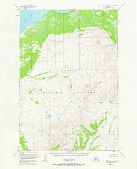
1953 Map of Mt. Katmai B-6
USGS Topo · Published 1967About this map
Katmai National Monument dominates this mid-century topographic study, which captures the raw, undeveloped character of the Alaska Peninsula before modern expansion. This specific quadrangle focuses on the transition from the shorelines of Lake Brooks in the north to the high elevation of Mt Kelez, where the terrain rises to 3,450 feet. The landscape is defined by its lack of human infrastructure, with no roads or trails indicated on the entire sheet, emphasizing the wilderness state of the region during the 1950s. Waterways like Contact Creek drain the southeast corner, carving through the mountainous interior. This map is a primary reference for understanding the hydrological and geological layout of the area as it was recorded shortly after the park's early years of federal protection.
Find a feature on this map
4 named features on this map. Tap any name to fly to it.
Don’t see what you’re looking for? This feature index may not catch every label — zoom into the map to look around manually.
Map Details
Editions of this 1953 Mt. Katmai B-6 Map
This is the sole edition of this map. No revisions or reprints were ever made.
Other maps of this area

1948 · Mt Katmai
USGS Topo · 1:250,000

1951 · Mt Katmai
USGS Topo · 1:250,000

1951 · Mount Katmai A-6
USGS Topo · 1:63,360

1951 · Mount Katmai C-6
USGS Topo · 1:63,360

1951 · Mount Katmai B-6
USGS Topo · 1:63,360

1951 · Naknek B-1
USGS Topo · 1:63,360

1951 · Naknek C-1
USGS Topo · 1:63,360

1951 · Mount Katmai C-5
USGS Topo · 1:63,360

1951 · Naknek A-1
USGS Topo · 1:63,360

1951 · Mount Katmai B-5
USGS Topo · 1:63,360