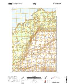
2019 Map of Mount Katmai B-6 NW
USGS Topo · Published 2019About this map
Lake Brooks dominates the northern reaches of this Alaskan wilderness within the expansive Katmai National Park. The landscape is defined by the sharp transition from the lake's southern shores to the steep, rising elevation of the interior. Surveyed in 2019, this map details a region where the natural environment remains largely untouched by development, focusing instead on the topographic contours that define the drainage basins and ridgelines. The absence of roads or established settlements emphasizes the character of the Lake and Peninsula Borough as a strictly wild landscape, where the primary landmarks are significant water bodies and the protected boundaries of the national park system.
Find a feature on this map
8 named features on this map. Tap any name to fly to it.
Don’t see what you’re looking for? This feature index may not catch every label — zoom into the map to look around manually.
Map Details
Editions of this 2019 Mount Katmai B-6 NW Map
This is the sole edition of this map. No revisions or reprints were ever made.
Other maps of this area

1948 · Mt Katmai
USGS Topo · 1:250,000

1951 · Mt Katmai
USGS Topo · 1:250,000

1951 · Mount Katmai C-6
USGS Topo · 1:63,360

1951 · Mount Katmai B-6
USGS Topo · 1:63,360

1951 · Naknek B-1
USGS Topo · 1:63,360

1951 · Naknek C-1
USGS Topo · 1:63,360

1952 · Naknek
USGS Topo · 1:250,000
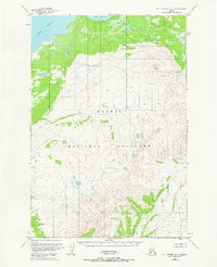
1953 · Mt. Katmai B-6
USGS Topo · 1:63,360

1964 · Mt. Katmai
USGS Topo · 1:250,000

1964 · Naknek
USGS Topo · 1:250,000