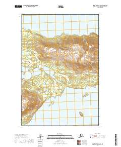
2019 Map of Mount Katmai C-6 SW
USGS Topo · Published 2019About this map
Katmai National Park encompasses this wilderness area where the northern waters of Naknek Lake meet the rising slopes of the Aleutian Range. The topography is dominated by Dumpling Mtn, a significant landmark rising above the shoreline that serves as a primary navigational point for the region. To the south, Lake Brooks defines the landscape, connected to the larger lake system by a narrow strip of land. This 2019 survey documents the primitive infrastructure of the park, specifically highlighting the Dumpling Mountain Trail as it ascends from the lake level toward the summit. The map provides a clear record of the glacial-carved geography and hydrology essential to the local ecosystem before any further modern development or environmental shifts alter these protected lands.
Find a feature on this map
5 named features on this map. Tap any name to fly to it.
Don’t see what you’re looking for? This feature index may not catch every label — zoom into the map to look around manually.
Map Details
Editions of this 2019 Mount Katmai C-6 SW Map
This is the sole edition of this map. No revisions or reprints were ever made.
Other maps of this area

1948 · Mt Katmai
USGS Topo · 1:250,000

1951 · Mt Katmai
USGS Topo · 1:250,000

1951 · Mount Katmai C-6
USGS Topo · 1:63,360

1951 · Mount Katmai B-6
USGS Topo · 1:63,360

1951 · Naknek B-1
USGS Topo · 1:63,360

1951 · Naknek C-1
USGS Topo · 1:63,360

1952 · Naknek
USGS Topo · 1:250,000
1953 · Mt. Katmai B-6
USGS Topo · 1:63,360

1964 · Mt. Katmai
USGS Topo · 1:250,000

1964 · Naknek
USGS Topo · 1:250,000