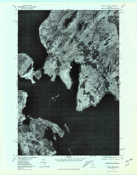
1977 Map of Mount Kineo
USGS Topo · Published 1981About this map
Moosehead Lake dominates this orthophotographic study, which utilizes aerial imagery taken in late 1977 to document the Maine wilderness. The prominent geological formation of Mount Kineo rises sharply along the shoreline, mirrored by the higher elevations of Little Kineo Mountain to the north. Unlike traditional line-drawn maps, this photo-based record shows the actual texture of the forest canopy and the precise reach of the shoreline during the late autumn season. The small settlement at Rockwood serves as the primary human landmark in an area defined by timber and water. Significant hydrological features including North Bay and the West Outlet are clearly visible, as is the winding course of Cowan Creek through the dense woods east of the main lake body.
Find a feature on this map
7 named features on this map. Tap any name to fly to it.
Don’t see what you’re looking for? This feature index may not catch every label — zoom into the map to look around manually.
Map Details
Editions of this 1977 Mount Kineo Map
This is the sole edition of this map. No revisions or reprints were ever made.
Other maps of this area

1920 · Moosehead Lake
USGS Topo · 1:62,500

1921 · Brassua Lake
USGS Topo · 1:62,500

1922 · Moosehead Lake
USGS Topo · 1:62,500

1923 · Brassua Lake
USGS Topo · 1:62,500

1930 · Moosehead Lake
USGS Topo · 1:62,500

1944 · Brassua Lake
USGS Topo · 1:62,500

1944 · Moosehead Lake
USGS Topo · 1:62,500

1954 · Seboomook Lake
USGS Topo · 1:62,500

1954 · North East Carry
USGS Topo · 1:62,500

1954 · Millinocket
USGS Topo · 1:250,000
Featured Places
- Misery Gore, ME
- Days Academy Grant Township, ME
- Spencer Bay Township, ME
- Sandbar Tract Township, ME
- Kineo Township, ME