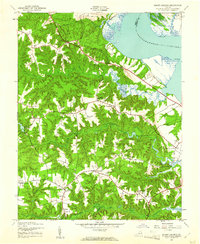
1944 Map of Mount Landing
USGS Topo · Published 1961About this map
The Rappahannock River defines the northeastern boundary of this survey, where the marshy expanse of Mulberry Island and the tidal waters of Mount Landing Creek meet the shoreline. Inland, the landscape is a network of small agricultural settlements and rural junctions characteristic of tidewater Virginia in the mid-1940s. The area is dotted with local landmarks including Mt Zion Ch, St John Ch, and the Hickory Road School, which served the dispersed community around Dunbrooke and Rexburg. Water management for local industry is evident at Motley Millpond and another Millpond along Hoskink Swamp. The topography is marked by numerous small forks and landings, such as Whitlock Forks and Upper Mount Landing, connected by a winding road system that includes a dedicated Landing Strip near the river. This survey, mapped by the Army Map Service, captures the region before the modernization of the mid-20th century.
Find a feature on this map
34 named features on this map. Tap any name to fly to it.
Don’t see what you’re looking for? This feature index may not catch every label — zoom into the map to look around manually.
Map Details
Editions of this 1944 Mount Landing Map
2 editions found

Other maps of this area

1889 · Fredericksburg
USGS Topo · 1:125,000

1892 · Fredericksburg
USGS Topo · 1:125,000

1892 · Montross
USGS Topo · 1:62,500

1894 · Fredericksburg
USGS Topo · 1:125,000

1895 · Nomini
USGS Topo · 1:125,000

1895 · Montross
USGS Topo · 1:62,500

1898 · Nomini
USGS Topo · 1:125,000

1918 · Tappahannock
USGS Topo · 1:62,500

1918 · Aylett
USGS Topo · 1:62,500

1919 · Tappahannock
USGS Topo · 1:62,500