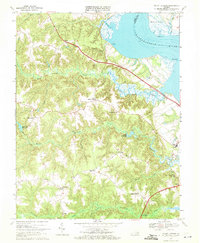
1968 Map of Mount Landing
USGS Topo · Published 1971About this map
The Rappahannock River defines the northeastern boundary of this Essex County landscape, where tidal marshes and numerous creeks like Mount Landing Creek cut through the coastal plain. Inland, the settlement pattern reflects Virginia's rural heritage, with small communities and church-centered crossroads such as Caret, Desha, and Kino dotting the terrain. The map captures a moment of infrastructure growth, specifically noting highway segments under construction near Henley Fork.
Find a feature on this map
43 named features on this map. Tap any name to fly to it.
Don’t see what you’re looking for? This feature index may not catch every label — zoom into the map to look around manually.
Map Details
Editions of this 1968 Mount Landing Map
3 editions found
Other maps of this area

1889 · Fredericksburg
USGS Topo · 1:125,000

1892 · Fredericksburg
USGS Topo · 1:125,000

1892 · Montross
USGS Topo · 1:62,500

1894 · Fredericksburg
USGS Topo · 1:125,000

1895 · Nomini
USGS Topo · 1:125,000

1895 · Montross
USGS Topo · 1:62,500

1898 · Nomini
USGS Topo · 1:125,000

1918 · Tappahannock
USGS Topo · 1:62,500

1918 · Aylett
USGS Topo · 1:62,500

1919 · Tappahannock
USGS Topo · 1:62,500