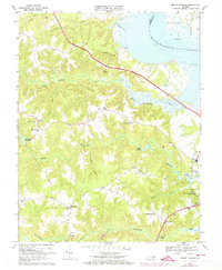
1968 Map of Mount Landing
USGS Topo · Published 1974About this map
Rappahannock River shorelines define the northeastern boundary of this Essex County landscape, where tidal marshes and islands like Mulberry Island meet the high ground of the Virginia coastal plain. The map reveals a rural economy centered on historically established crossroads and water-powered sites, evidenced by Cheatwood Millpond and Scotts Millpond. Small communities such as Upper Mount Landing and Rexburg are connected by a network of winding roads, many leading toward the more modern corridor of Route 17. Local religious and social foundations are well-represented by several country churches, including Hermon Ch, First Union Ch, and Mt Zion Ch near Dunbrooke. The interior is characterized by significant wetlands like Criddlin Swamp and Sturgeon Swamp, which drain into the meandering Hoskins Creek and Piscataway Creek, illustrating the intricate drainage patterns that have long influenced settlement and land use in this part of the Tidewater region.
Find a feature on this map
40 named features on this map. Tap any name to fly to it.
Don’t see what you’re looking for? This feature index may not catch every label — zoom into the map to look around manually.
Map Details
Editions of this 1968 Mount Landing Map
3 editions found
Other maps of this area

1889 · Fredericksburg
USGS Topo · 1:125,000

1892 · Fredericksburg
USGS Topo · 1:125,000

1892 · Montross
USGS Topo · 1:62,500

1894 · Fredericksburg
USGS Topo · 1:125,000

1895 · Nomini
USGS Topo · 1:125,000

1895 · Montross
USGS Topo · 1:62,500

1898 · Nomini
USGS Topo · 1:125,000

1918 · Tappahannock
USGS Topo · 1:62,500

1918 · Aylett
USGS Topo · 1:62,500

1919 · Tappahannock
USGS Topo · 1:62,500