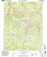
2001 Map of Mount Linnaeus
USGS Topo · Published 2004About this map
The Abajo Mountains dominate this high-altitude landscape within the Manti-La Sal National Forest, where steep canyons and high ridges converge at Mount Linnaeus. The terrain is marked by a network of seasonal water sources and isolated human outposts, including Bayles Ranch and several high-country shelters like Blue Creek Cabin and Duckett Cabin. A complex drainage system defines the local geography, with Deep Canyon and Mule Canyon carving through the plateau toward the south, while the The Causeway provides a distinct geographic spine between the canyons. Water management is evident in the presence of the Blue Creek Reservoir and the Dry Wash Reservoir, likely serving livestock or forest management in this arid environment. The naming of landmarks like Skull and Crossbones and Cliff Dwellers Pasture hints at the local lore and archaeological depth of this section of San Juan County.
Find a feature on this map
51 named features on this map. Tap any name to fly to it.
Don’t see what you’re looking for? This feature index may not catch every label — zoom into the map to look around manually.
Map Details
Editions of this 2001 Mount Linnaeus Map
This is the sole edition of this map. No revisions or reprints were ever made.
Other maps of this area

1886 · Abajo
USGS Topo · 1:250,000

1892 · Abajo
USGS Topo · 1:250,000

1893 · Abajo
USGS Topo · 1:250,000

1935 · Elk Ridge
USGS Topo · 1:96,000

1940 · Elk Ridge
USGS Topo · 1:125,000

1954 · Elk Ridge 4 NW
USGS Topo · 1:24,000

1954 · Elk Ridge 1 SW
USGS Topo · 1:24,000

1954 · Elk Ridge 1 NW
USGS Topo · 1:24,000

1954 · Elk Ridge 1 NE
USGS Topo · 1:24,000

1954 · Elk Ridge 1 SE
USGS Topo · 1:24,000