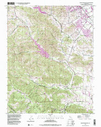
1996 Map of Mount Madonna
USGS Topo · Published 2000About this map
Morgan Hill anchors the northeast corner of this Santa Clara County landscape, where the Santa Clara Valley transitions into the foothills of the Santa Cruz Mountains. The terrain is defined by significant water management features, including the large Chesbro Reservoir and Uvas Reservoir, which capture runoff from Llagas Creek and Uvas Creek. Historical land patterns are still visible through the boundaries of old Mexican land grants like San Francisco de las Llagas and Ojo de Agua de la Coche. Further south, the map details the rugged ascent toward Mount Madonna County Park, passing the secluded settlement at Redwood Retreat. This survey documents a mid-1990s view of the area's geography, showing the spatial relationship between growing suburban infrastructure and the prominent San Andreas Fault Zone tracing the western ridges.
Find a feature on this map
38 named features on this map. Tap any name to fly to it.
Don’t see what you’re looking for? This feature index may not catch every label — zoom into the map to look around manually.
Map Details
Editions of this 1996 Mount Madonna Map
This is the sole edition of this map. No revisions or reprints were ever made.
Other maps of this area

1912 · Capitola
USGS Topo · 1:62,500

1914 · Capitola
USGS Topo · 1:62,500

1915 · San Juan Bautista
USGS Topo · 1:48,000

1916 · New Almaden
USGS Topo · 1:48,000

1917 · Morgan Hill
USGS Topo · 1:62,500

1917 · San Juan Bautista
USGS Topo · 1:62,500

1919 · New Almaden
USGS Topo · 1:62,500

1939 · Morgan Hill
USGS Topo · 1:62,500

1939 · San Juan Bautista
USGS Topo · 1:62,500

1940 · San Juan Bautista
USGS Topo · 1:62,500