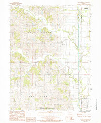
1984 Map of Mount Moriah
USGS Topo · Published 1985About this map
Mount Moriah sits as the central hub of this Missouri landscape, situated near the intersection of several northern townships including Trail Creek and Fox Creek. This 1980s survey captures a rural environment defined by its waterways, most notably the meandering Thompson River which forms a significant boundary on the eastern edge of the quadrangle. The terrain is deeply etched by a network of drainage systems such as Panther Creek, Sandy Creek, and Queens Branch, illustrating the typical dissected till plains of the region.
Find a feature on this map
18 named features on this map. Tap any name to fly to it.
Don’t see what you’re looking for? This feature index may not catch every label — zoom into the map to look around manually.
Map Details
Editions of this 1984 Mount Moriah Map
This is the sole edition of this map. No revisions or reprints were ever made.
Other maps of this area

1925 · Gilman
USGS Topo · 1:62,500

1946 · Gilman
USGS Topo · 1:48,000

1946 · Princeton
USGS Topo · 1:62,500

1947 · Blythedale
USGS Topo · 1:62,500

1948 · Gilman
USGS Topo · 1:62,500

1948 · Princeton
USGS Topo · 1:62,500

1948 · Trenton
USGS Topo · 1:62,500

1954 · Centerville
USGS Topo · 1:250,000

1957 · Centerville
USGS Topo · 1:250,000

1958 · Centerville
USGS Topo · 1:250,000