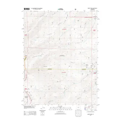
2013 Map of Mount Ouray
USGS Topo · Published 2013About this map
Mount Ouray stands as the dominant topographical feature of this high-altitude landscape, marking a significant point along the boundary of Chaffee and Saguache Counties. The area is defined by the intersection of the San Isabel National Forest and Gunnison National Forest, creating a massive corridor of protected wilderness where drainage systems like Poncha Creek and Little Cochetopa Creek carve through the steep terrain. Historic transportation routes and modern recreation overlap here, with the Marshall Pass Road and the Rainbow Trail 1336 providing access to remote landmarks such as the Devils Armchair. High-altitude water bodies, including Lake O'Haver and the Silver Creek Lakes, anchor local activity points like the O'Haver Lake Campground. This survey illustrates the intricate network of forest service trails, including the Starvation Creek Trail 1408 and Pass Creek Trail 1411, that connect these peaks and ranching sites like Blanchard Ranch.
Find a feature on this map
45 named features on this map. Tap any name to fly to it.
Don’t see what you’re looking for? This feature index may not catch every label — zoom into the map to look around manually.
Map Details
Editions of this 2013 Mount Ouray Map
This is the sole edition of this map. No revisions or reprints were ever made.
Other maps of this area

1940 · Garfield
USGS Topo · 1:62,500

1945 · Garfield
USGS Topo · 1:62,500

1956 · Poncha Springs
USGS Topo · 1:62,500

1956 · Montrose
USGS Topo · 1:250,000

1959 · Montrose
USGS Topo · 1:250,000

1959 · Bonanza
USGS Topo · 1:62,500

1960 · Montrose
USGS Topo · 1:250,000

1967 · Chester
USGS Topo · 1:24,000

1967 · Pahlone Peak
USGS Topo · 1:24,000

1968 · Montrose
USGS Topo · 1:250,000