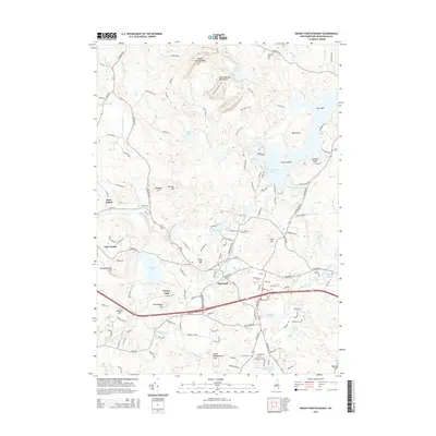
2015 Map of Mount Pawtuckaway
USGS Topo · Published 2015About this map
The town of Raymond and the surrounding Rockingham County woodlands are defined by a complex network of glacial ponds and the winding Lamprey River. In this 2015 update, the landscape shows a mix of dense forest and residential expansion, particularly around Governors Lake and Onway Lake. The northeastern corner is dominated by the Pawtuckaway Mountains, featuring landmarks like Mount Pawtuckaway and Tavern Hill. Recreational trails such as the Shaw Trail and Split Rock Trail crisscross the mountain area, while the Pawtuckaway Pond shoreline is marked by prominent features like Horse Island and Seamans Point. Local history is preserved in sites like Gove Cem and the settlement of East Candia to the west. This map illustrates the modern balance between conserved wilderness and the residential corridors that follow historic routes like Raymond Rd and Deerfield Rd.
Find a feature on this map
136 named features on this map. Tap any name to fly to it.
Don’t see what you’re looking for? This feature index may not catch every label — zoom into the map to look around manually.
Map Details
Editions of this 2015 Mount Pawtuckaway Map
This is the sole edition of this map. No revisions or reprints were ever made.
Other maps of this area

1888 · Haverhill
USGS Topo · 1:62,500

1890 · Haverhill
USGS Topo · 1:62,500

1893 · Haverhill
USGS Topo · 1:62,500

1905 · Manchester
USGS Topo · 1:62,500

1917 · Mt. Pawtuckaway
USGS Topo · 1:62,500

1919 · Mt. Pawtuckaway
USGS Topo · 1:62,500

1921 · Suncook
USGS Topo · 1:62,500

1935 · Haverhill
USGS Topo · 1:62,500

1939 · Mt. Pawtuckaway
USGS Topo · 1:62,500

1941 · Manchester
USGS Topo · 1:62,500