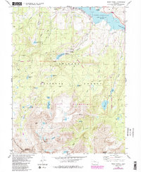
1980 Map of Mount Powell
USGS Topo · Published 1988About this map
The settlement of Heeney sits along the northern edge of the Green Mountain Reservoir, where the Blue River flows into the expansive body of water. This 1980s-era map documents a landscape defined by high alpine peaks and an intricate network of waterways within the Arapaho National Forest and White River National Forest. To the south and west, the terrain rises sharply toward Mount Powell and Eagles Nest, marking the protected reaches of the Eagles Nest Wilderness. The survey captures the recreational infrastructure of the time, including the Elliott Creek Campground and Cataract Campground, alongside early water management features like Hoagland Reservoir No 1 and various Gaging Sta points. A complex system of drainages, including Elliott Creek and Cataract Creek, feeds numerous high-elevation lakes such as Lower Cataract Lake and Tipperary Lake, illustrating the hydrologic character of the Summit and Eagle County border.
Find a feature on this map
39 named features on this map. Tap any name to fly to it.
Don’t see what you’re looking for? This feature index may not catch every label — zoom into the map to look around manually.
Map Details
Editions of this 1980 Mount Powell Map
3 editions found
Other maps of this area

1929 · Dillon
USGS Topo · 1:62,500

1933 · Mt. Powell
USGS Topo · 1:48,000

1933 · Ute Peak
USGS Topo · 1:62,500

1934 · Minturn
USGS Topo · 1:62,500

1934 · Dillon
USGS Topo · 1:62,500

1937 · Ute Peak
USGS Topo · 1:62,500

1940 · Mount Powell
USGS Topo · 1:62,500

1950 · Minturn
USGS Topo · 1:62,500

1957 · Leadville
USGS Topo · 1:250,000

1959 · Leadville
USGS Topo · 1:250,000