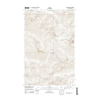
2014 Map of Mount Redoubt
USGS Topo · Published 2014About this map
Mt Redoubt dominates this high-altitude landscape within North Cascades National Park, providing a record of the complex glacial and hydrologic systems of northern Whatcom County. The terrain is characterized by massive elevation changes, punctuated by features like the Redoubt Glacier and the steep Ridge of Gendarmes. For those studying the history of recreation and conservation in the Pacific Northwest, the map traces the critical route of the Pacific NW National Scenic Trail as it crosses Whatcom Pass and Beaver Pass. This survey illustrates the relationship between these high ridges and the drainage basins of Depot Cr, Indian Cr, and Little Beaver Cr. Notable landmarks such as Nodoubt Peak, Bear Mtn, and the high-alpine Lake Reveille highlight the primitive, protected nature of this wilderness area at the beginning of the 21st century.
Find a feature on this map
31 named features on this map. Tap any name to fly to it.
Don’t see what you’re looking for? This feature index may not catch every label — zoom into the map to look around manually.
Map Details
Editions of this 2014 Mount Redoubt Map
This is the sole edition of this map. No revisions or reprints were ever made.
Other maps of this area
1953 · Mt Challenger
USGS Topo · 1:62,500

1955 · Concrete
USGS Topo · 1:250,000

1958 · Concrete
USGS Topo · 1:250,000

1962 · Concrete
USGS Topo · 1:250,000
1969 · Mt Prophet
USGS Topo · 1:24,000
1969 · Mt Spickard
USGS Topo · 1:24,000
1979 · Mt. Baker
USGS Topo · 1:100,000
1989 · Copper Mountain
USGS Topo · 1:24,000
1989 · Mount Blum
USGS Topo · 1:24,000
1989 · Mt Challenger
USGS Topo · 1:24,000