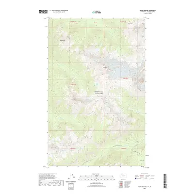
2020 Map of Mount Redoubt
USGS Topo · Published 2020About this map
North Cascades National Park dominates this high-altitude landscape, centered on the formidable mass of Mt Redoubt and the surrounding Redoubt Glacier. The map details a complex glacial environment where sharp peaks like Nodoubt Peak and the Mox Peaks rise above deep-cut drainage systems. To the south, the Pacific NW National Scenic Trail traverses the high country, passing through Beaver Pass and skirting the headwaters of Brush Creek. The concentration of alpine water bodies, including Lake Réveille, the Tapto Lakes, and East Lakes, illustrates the active glaciated hydrology of the northern Cascades. This 2020 survey captures the modern extent of these ice fields and the established trail networks used by backcountry explorers to navigate between ridges like the Ridge of Gendarmes and Red Face Mtn.
Find a feature on this map
37 named features on this map. Tap any name to fly to it.
Don’t see what you’re looking for? This feature index may not catch every label — zoom into the map to look around manually.
Map Details
Editions of this 2020 Mount Redoubt Map
This is the sole edition of this map. No revisions or reprints were ever made.
Other maps of this area
1953 · Mt Challenger
USGS Topo · 1:62,500

1955 · Concrete
USGS Topo · 1:250,000

1958 · Concrete
USGS Topo · 1:250,000

1962 · Concrete
USGS Topo · 1:250,000
1969 · Mt Prophet
USGS Topo · 1:24,000
1969 · Mt Spickard
USGS Topo · 1:24,000
1979 · Mt. Baker
USGS Topo · 1:100,000
1989 · Copper Mountain
USGS Topo · 1:24,000
1989 · Mount Blum
USGS Topo · 1:24,000
1989 · Mt Challenger
USGS Topo · 1:24,000