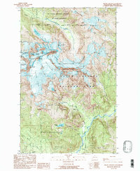
1989 Map of Mount Shuksan
USGS Topo · Published 1989About this map
Mt Shuksan serves as the central massif of this high-altitude landscape, where the convergence of the North Cascades National Park, Mt Baker National Forest, and Mt Baker Wilderness boundaries creates a complex administrative mosaic. The sheet is defined by its massive glacial systems, including the extensive Sulphide Glacier and East Nooksack Glacier, which feed the drainages of the North Fork Nooksack River and the Baker River. High-relief features like Nooksack Tower and the Summit Pyramid overlook the Nooksack Cirque, illustrating a terrain shaped by heavy ice and significant elevation changes. For the historical researcher, the map documents the late 20th-century state of these permanent ice fields and the specific placement of the Wilderness Boundary during the 1980s. Local landmarks such as Price Lake and Shuksan Lake are caught between the rock ribs of Jagged Ridge and Seahpo Peak.
Find a feature on this map
40 named features on this map. Tap any name to fly to it.
Don’t see what you’re looking for? This feature index may not catch every label — zoom into the map to look around manually.
Map Details
Editions of this 1989 Mount Shuksan Map
2 editions found
Other maps of this area

1909 · Mt Baker
USGS Topo · 1:192,000

1915 · Mt. Baker
USGS Topo · 1:250,000

1952 · Lake Shannon
USGS Topo · 1:62,500

1953 · Mt Shuksan
USGS Topo · 1:62,500

1953 · Marblemount
USGS Topo · 1:62,500

1953 · Mt Challenger
USGS Topo · 1:62,500

1955 · Concrete
USGS Topo · 1:250,000

1958 · Concrete
USGS Topo · 1:250,000

1962 · Concrete
USGS Topo · 1:250,000

1979 · Mt. Baker
USGS Topo · 1:100,000