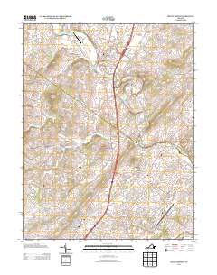
2013 Map of Mount Sidney
USGS Topo · Published 2013About this map
Mount Sidney and Mount Crawford anchor this survey of the Shenandoah Valley, where Interstate 81 and Route 11 parallel the ancient Great Wagon Road corridor. The landscape is defined by the winding course of the North River and its numerous tributaries, including Cooks Creek and Naked Creek. Small agricultural communities and landmarks like Stonewall and Friedens are interspersed with modern infrastructure such as the Shenandoah Valley Regional Airport and Bridgewater Air Park.
Find a feature on this map
130 named features on this map. Tap any name to fly to it.
Don’t see what you’re looking for? This feature index may not catch every label — zoom into the map to look around manually.
Map Details
Editions of this 2013 Mount Sidney Map
This is the sole edition of this map. No revisions or reprints were ever made.
Other maps of this area

1892 · Harrisonburg
USGS Topo · 1:125,000

1894 · Staunton
USGS Topo · 1:125,000

1934 · Waynesboro
USGS Topo · 1:48,000

1939 · Waynesboro
USGS Topo · 1:62,500

1941 · Harrisonburg
USGS Topo · 1:62,500

1943 · Harrisonburg
USGS Topo · 1:62,500

1944 · Parnassus
USGS Topo · 1:62,500

1944 · Staunton
USGS Topo · 1:62,500

1947 · Staunton
USGS Topo · 1:62,500

1947 · Parnassus
USGS Topo · 1:62,500