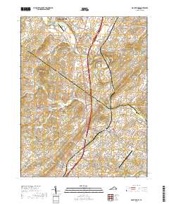
2019 Map of Mount Sidney
USGS Topo · Published 2019About this map
Mount Crawford and Bridgewater anchor the northern landscape of this region, where the North River and Cooks Creek converge near the Rockingham and Augusta county line. The map highlights a critical transportation and educational corridor, centered on the Blue Ridge Community College Weyers Cave Campus and the nearby Shenandoah Valley Regional Airport. This 2019 survey documents the modern layout of rural settlements like Burketown and Mount Sidney while preserving the location of numerous historic burial grounds.
Find a feature on this map
138 named features on this map. Tap any name to fly to it.
Don’t see what you’re looking for? This feature index may not catch every label — zoom into the map to look around manually.
Map Details
Editions of this 2019 Mount Sidney Map
This is the sole edition of this map. No revisions or reprints were ever made.
Other maps of this area

1892 · Harrisonburg
USGS Topo · 1:125,000

1894 · Staunton
USGS Topo · 1:125,000

1934 · Waynesboro
USGS Topo · 1:48,000

1939 · Waynesboro
USGS Topo · 1:62,500

1941 · Harrisonburg
USGS Topo · 1:62,500

1943 · Harrisonburg
USGS Topo · 1:62,500

1944 · Parnassus
USGS Topo · 1:62,500

1944 · Staunton
USGS Topo · 1:62,500

1947 · Staunton
USGS Topo · 1:62,500

1947 · Parnassus
USGS Topo · 1:62,500