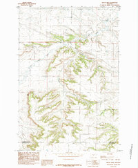
1985 Map of Mount Sinai
USGS Topo · Published 1985About this map
Mount Sinai rises as a prominent landmark in this 1980s landscape, positioned near the boundary of Golden Valley Co and Stillwater Co. The terrain is defined by a dense network of coulees and gulches that channel water through the high plains. Drainage patterns are dominated by Big Coulee Creek in the north and Custer Creek which cuts through the central sections of the quadrangle. Other smaller watercourses, such as Stockade Gulch, Cabin Gulch Creek, and Hop Creek, illustrate the complex erosion and topographical relief characteristic of this part of Montana. This provisional survey captures the area's rural character, showing a sparse network of unimproved roads and transmission lines that navigate the deep ravines and ridges. The map provides a detailed view of the natural landforms before modern development, recording the exact placement of summits and drainages that have served as local reference points for generations.
Find a feature on this map
7 named features on this map. Tap any name to fly to it.
Don’t see what you’re looking for? This feature index may not catch every label — zoom into the map to look around manually.
Map Details
Editions of this 1985 Mount Sinai Map
This is the sole edition of this map. No revisions or reprints were ever made.
Other maps of this area

1889 · Big Snowy Mountain
USGS Topo · 1:250,000

1893 · Big Snowy Mountain
USGS Topo · 1:250,000

1954 · Roundup
USGS Topo · 1:250,000

1958 · Roundup
USGS Topo · 1:250,000
1985 · Hailstone Basin
USGS Topo · 1:24,000
1985 · Hailstone Basin SE
USGS Topo · 1:24,000
1985 · Locomotive Butte
USGS Topo · 1:24,000
1985 · Locomotive Butte SE
USGS Topo · 1:24,000
1985 · Eagle Point
USGS Topo · 1:24,000

1986 · Ryegate West
USGS Topo · 1:24,000