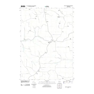
2010 Map of Mount Sterling
USGS Topo · Published 2010About this map
Mount Sterling and Seneca anchor this Crawford County landscape, where the topography is defined by a series of high ridges and deep hollows characteristic of the Driftless Area. The map documents a rural environment organized around family-named features and local heritage sites, including Mickelson Ridge, Boma Ridge, and Sime Ridge. Waterways such as North Branch Copper Creek and Halls Branch carve through the elevation, while the Blackhawk-Kickapoo Project G8735.2 Dam indicates mid-century watershed management efforts. For genealogists, the map provides precise locations for several burial grounds, including the Saint Patricks Cemetery near Seneca and the Pioneer Cemetery east of Mount Sterling. The network of local roads, such as Taylor Ridge Rd and Olson Feed Rd, follows the natural contours of the land, connecting the small settlements of Fairview and Pleasant Ridge to the larger agricultural community.
Find a feature on this map
62 named features on this map. Tap any name to fly to it.
Don’t see what you’re looking for? This feature index may not catch every label — zoom into the map to look around manually.
Map Details
Editions of this 2010 Mount Sterling Map
This is the sole edition of this map. No revisions or reprints were ever made.
Other maps of this area

1903 · Waukon
USGS Topo · 1:125,000

1924 · Gays Mills
USGS Topo · 1:62,500

1926 · Gays Mills
USGS Topo · 1:62,500

1926 · Wauzeka
USGS Topo · 1:62,500

1929 · Ferryville
USGS Topo · 1:62,500

1929 · Prairie Du Chien
USGS Topo · 1:62,500

1932 · Ferryville
USGS Topo · 1:62,500

1932 · Prairie Du Chien
USGS Topo · 1:62,500

1958 · La Crosse
USGS Topo · 1:250,000

1961 · La Crosse
USGS Topo · 1:250,000