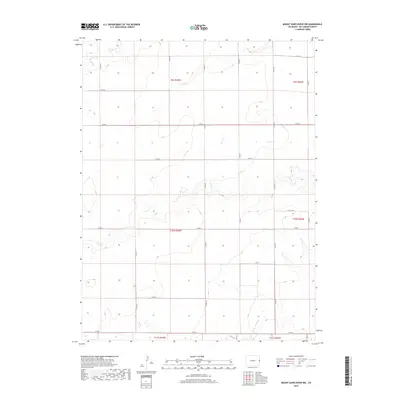
2019 Map of Mount Sunflower NW
USGS Topo · Published 2019About this map
N Fork Smoky Hill River anchors the southern reaches of this High Plains landscape, where the ephemeral drainages of Sandy Cr and Middle Beaver Cr carve subtle relief into the Kit Carson County terrain. This area of eastern Colorado is defined by the rigid grid of the Public Land Survey System, with township boundaries like t10s r43w and t9s r43w dictating the placement of the county road network. The map reveals a highly structured agricultural environment where section lines serve as the primary corridors for transport, including Co Rd R and Co Rd G. For those researching land use and rural development, the placement of these roads and the intermittent watercourses provide a clear picture of how water availability and legal boundaries shaped the settlement patterns of this prairie region in the early twenty-first century.
Find a feature on this map
25 named features on this map. Tap any name to fly to it.
Don’t see what you’re looking for? This feature index may not catch every label — zoom into the map to look around manually.
Map Details
Editions of this 2019 Mount Sunflower NW Map
This is the sole edition of this map. No revisions or reprints were ever made.
Other maps of this area

1954 · Limon
USGS Topo · 1:250,000

1957 · Limon
USGS Topo · 1:250,000

1958 · Limon
USGS Topo · 1:250,000
1969 · Mount Sunflower SW
USGS Topo · 1:24,000
1969 · Burlington 3 SE
USGS Topo · 1:24,000
1969 · Mount Sunflower
USGS Topo · 1:24,000
1969 · Burlington
USGS Topo · 1:24,000
1969 · Mount Sunflower NW
USGS Topo · 1:24,000
1969 · Mount Sunflower NE
USGS Topo · 1:24,000
1969 · Peconic
USGS Topo · 1:24,000