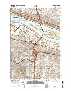
2014 Map of Mount Tabor
USGS Topo · Published 2014About this map
Government Island sits prominently within the Columbia River, separating the urban sprawl of Portland and Vancouver in this 2014 survey. The map details a complex intersection of transportation and topography, from the sprawling grounds of Portland International Airport to the elevated profile of Rocky Butte. The landscape is densely packed with established neighborhoods like Laurelhurst, Montavilla, and Hollywood, each defined by a precise grid of streets and local landmarks such as Brainerd Cem and Cascade Coll. Across the river in Washington, settlements like McLoughlin Heights and Ellsworth overlook the water from the north bank. This modern topographic record captures the area's intricate infrastructure, including the Sullivan Gulch Gateway / Northeast 99th Ave Transit Center and several municipal reservoirs, illustrating the high density of religious, educational, and transit facilities that define this Pacific Northwest metropolitan core.
Find a feature on this map
60 named features on this map. Tap any name to fly to it.
Don’t see what you’re looking for? This feature index may not catch every label — zoom into the map to look around manually.
Map Details
Editions of this 2014 Mount Tabor Map
This is the sole edition of this map. No revisions or reprints were ever made.
Other maps of this area

1897 · Portland
USGS Topo · 1:62,500

1905 · Portland
USGS Topo · 1:62,500

1911 · Boring
USGS Topo · 1:48,000

1914 · Boring
USGS Topo · 1:62,500

1914 · Oregon City
USGS Topo · 1:62,500

1916 · Estacada
USGS Topo · 1:125,000

1918 · Troutdale
USGS Topo · 1:62,500

1934 · Troutdale
USGS Topo · 1:48,000

1939 · Oregon City
USGS Topo · 1:62,500

1940 · Boring
USGS Topo · 1:62,500