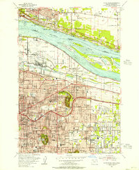
1954 Map of Mount Tabor
USGS Topo · Published 1956About this map
Mount Tabor and Rocky Butte anchor the landscape east of downtown Portland, serving as prominent volcanic landmarks in this mid-century portrait of suburban growth. The map illustrates the transition from the bustling Portland International Airport and Portland Air Force Base along the Columbia River to the residential grids of Montavilla, Parkrose, and Laurelhurst. The newly built Banfield Expressway and the Spokane Portland and Seattle railroad reflect the era's evolving transportation network, while the Grotto is identified as the Sanctuary of Our Sorrowful Mother north of Rocky Butte. Numerous parochial and public schools, such as St Rose Sch and Portland Union Academy, populate the growing neighborhoods, providing a detailed look at the social infrastructure during a period of significant expansion in eastern Multnomah County.
Find a feature on this map
86 named features on this map. Tap any name to fly to it.
Don’t see what you’re looking for? This feature index may not catch every label — zoom into the map to look around manually.
Map Details
Editions of this 1954 Mount Tabor Map
This is the sole edition of this map. No revisions or reprints were ever made.
Other maps of this area

1897 · Portland
USGS Topo · 1:62,500

1905 · Portland
USGS Topo · 1:62,500

1911 · Boring
USGS Topo · 1:48,000

1914 · Boring
USGS Topo · 1:62,500

1914 · Oregon City
USGS Topo · 1:62,500

1916 · Estacada
USGS Topo · 1:125,000

1918 · Troutdale
USGS Topo · 1:62,500

1934 · Troutdale
USGS Topo · 1:48,000

1939 · Oregon City
USGS Topo · 1:62,500

1940 · Boring
USGS Topo · 1:62,500