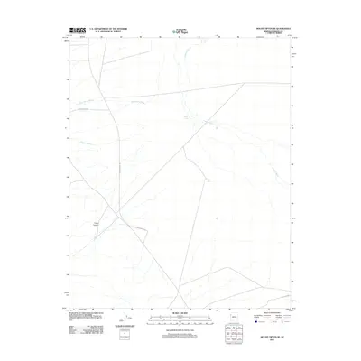
2011 Map of Mount Tipton SE
USGS Topo · Published 2011About this map
Tipton Canyon and the surrounding Mohave County drainage systems define this arid landscape, which is marked by the seasonal pathways of Truxton Wash and Cane Spring Wash. The area represents a sparsely developed segment of the Arizona desert, where human presence is primarily indicated by a network of rural access routes and small water catchments. These catchments, including White Tank and Canyon Tank, provide vital water points in a territory dominated by ephemeral watercourses like Twentysix Wash. The map documents the layout of regional transportation through the Hualapai Valley corridor, featuring significant local arteries such as Stockton Hill Rd, Cane Springs Rd, and the specific private or local access of D'Ambro Ranch Rd.
Find a feature on this map
10 named features on this map. Tap any name to fly to it.
Don’t see what you’re looking for? This feature index may not catch every label — zoom into the map to look around manually.
Map Details
Editions of this 2011 Mount Tipton SE Map
This is the sole edition of this map. No revisions or reprints were ever made.
Other maps of this area
1886 · Diamond Creek
USGS Topo · 1:250,000
1886 · Camp Mohave
USGS Topo · 1:250,000
1892 · Diamond Creek
USGS Topo · 1:250,000
1892 · Camp Mohave
USGS Topo · 1:250,000
1939 · Chloride
USGS Topo · 1:48,000
1942 · Camp Mohave
USGS Topo · 1:250,000
1944 · Chloride
USGS Topo · 1:62,500

1947 · Kingman
USGS Topo · 1:250,000

1948 · Kingman
USGS Topo · 1:250,000
1948 · Williams
USGS Topo · 1:250,000