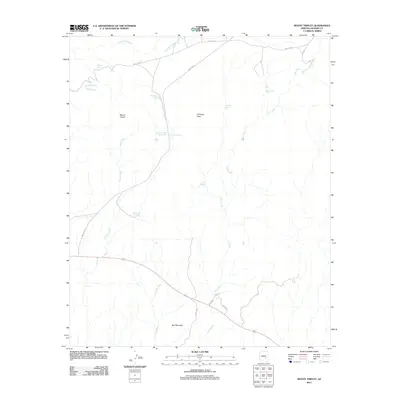
2011 Map of Mount Triplet
USGS Topo · Published 2011About this map
Mount Triplet and Salt Mountain anchor this high-desert landscape in Graham County, where the topography is defined by seasonal drainages and vital water catchments. The area is marked by a network of drainage washes including Triplet Wash, Coyote Wash, and the extensive Salt Creek system. Given the arid environment, the map meticulously documents essential water sources such as Hackberry Spring, Willow Spring, and Salt Spring, alongside man-made improvements like Triplets Tank and Salt Creek Tank. Access is limited to remote corridors like Triplets Rd and Indian Rte 8, which skirt the edges of Antelope Flats. The southern portion of the quadrangle is bisected by Highway 70, providing a primary artery through this sparsely settled territory. The arrangement of these cattle tanks and springs suggests a landscape primarily utilized for range and transit rather than dense settlement.
Find a feature on this map
23 named features on this map. Tap any name to fly to it.
Don’t see what you’re looking for? This feature index may not catch every label — zoom into the map to look around manually.
Map Details
Editions of this 2011 Mount Triplet Map
This is the sole edition of this map. No revisions or reprints were ever made.
Other maps of this area
1954 · Mesa
USGS Topo · 1:250,000
1957 · Mesa
USGS Topo · 1:250,000
1958 · Mesa
USGS Topo · 1:250,000
1960 · Mesa
USGS Topo · 1:250,000
1960 · Bylas
USGS Topo · 1:62,500
1962 · San Carlos Reservoir
USGS Topo · 1:62,500
1964 · Mesa
USGS Topo · 1:250,000
1965 · Sontag Mesa
USGS Topo · 1:24,000
1966 · Branaman Spring
USGS Topo · 1:24,000
1966 · Natural Corral
USGS Topo · 1:24,000