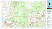
1986 Map of Mount Trumbull
USGS Topo · Published 1987About this map
The Colorado River carves through the heart of this landscape, marking the dramatic transition from the Shiwits Plateau to the Uinkaret Plateau. This 1986 edition records a territory defined by its extreme verticality and isolation, where historical mining operations like the Grand Gulch Mine and Cunningham Mine established small footholds in the desert. The map captures the meeting of several major protected areas, including Grand Canyon National Park and the Lake Mead National Recreation Area. Significant peaks such as Mount Trumbull, Mount Logan, and Mount Emma dominate the high ground above the Hurricane Cliffs. Along the river itself, treacherous features like Lava Falls Rapids and Separation Rapids are documented, while high points like Snap Point and Kelly Point overlook the vast canyon system.
Find a feature on this map
47 named features on this map. Tap any name to fly to it.
Don’t see what you’re looking for? This feature index may not catch every label — zoom into the map to look around manually.
Map Details
Editions of this 1986 Mount Trumbull Map
2 editions found
Other maps of this area

1886 · Diamond Creek
USGS Topo · 1:250,000

1886 · Camp Mohave
USGS Topo · 1:250,000

1886 · Saint Thomas
USGS Topo · 1:250,000

1886 · Mt. Trumbull
USGS Topo · 1:250,000

1886 · Chino
USGS Topo · 1:250,000

1886 · Kaibab
USGS Topo · 1:250,000

1891 · Chino
USGS Topo · 1:250,000

1892 · Diamond Creek
USGS Topo · 1:250,000

1892 · Mt. Trumbull
USGS Topo · 1:250,000

1892 · Camp Mohave
USGS Topo · 1:250,000