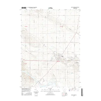
2015 Map of Mount Vernon
USGS Topo · Published 2015About this map
Mount Vernon and Lisbon form the primary population centers on this Linn County landscape, where the historic campus of Cornell Coll stands at the heart of the community. The terrain is defined by a series of north-south running creeks, including Elbow Cr and Abbe Cr, which drain into the meandering Cedar River at the southwestern corner. This area preserves a high density of burial grounds that mark the heritage of early settler families, such as Abbe Creek Cem, Craig Cem, and Mount Zion Cem. The road network follows a rigid section-line grid typical of the Midwest, though it bends to accommodate the physical contours of the river valley. To the southeast, the Saint John Catholic Cemetery and Lisbon Cem are significant sites for genealogical research, documenting the long-standing community foundations in this part of eastern Iowa.
Find a feature on this map
90 named features on this map. Tap any name to fly to it.
Don’t see what you’re looking for? This feature index may not catch every label — zoom into the map to look around manually.
Map Details
Editions of this 2015 Mount Vernon Map
This is the sole edition of this map. No revisions or reprints were ever made.
Other maps of this area
1887 · Cedar Rapids
USGS Topo · 1:62,500
1888 · Marion
USGS Topo · 1:62,500
1889 · Marion
USGS Topo · 1:62,500
1890 · Anamosa
USGS Topo · 1:62,500
1891 · Mechanicsville
USGS Topo · 1:62,500
1891 · Cedar Rapids
USGS Topo · 1:62,500
1894 · Mechanicsville
USGS Topo · 1:62,500
1900 · Anamosa
USGS Topo · 1:125,000
1901 · Stanwood
USGS Topo · 1:125,000
1903 · Fairfax
USGS Topo · 1:125,000