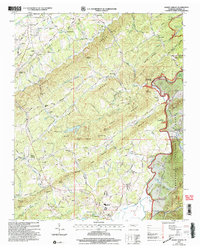
2003 Map of Mount Vernon
USGS Topo · Published 2004About this map
The Tellico River and its accompanying Tellico Lake reservoir define the eastern edge of this East Tennessee landscape, where the valley floor meets the rising peaks of the Cherokee National Forest. This 2003 revision, based on earlier surveys, captures a complex network of rural infrastructure including Stakely Mill and Belltown Mill along the watercourses. The interior is characterized by the distinctive terrain of the Knobs and Notchy Ridge, which separate major drainages like Notchy Creek and Big Creek.
Find a feature on this map
78 named features on this map. Tap any name to fly to it.
Don’t see what you’re looking for? This feature index may not catch every label — zoom into the map to look around manually.
Map Details
Editions of this 2003 Mount Vernon Map
This is the sole edition of this map. No revisions or reprints were ever made.
Other maps of this area

1893 · Murphy
USGS Topo · 1:125,000

1895 · Loudon
USGS Topo · 1:125,000

1914 · Murphy
USGS Topo · 1:125,000

1933 · Haw Knob
USGS Topo · 1:48,000

1933 · Bald River Falls
USGS Topo · 1:24,000

1933 · Rafter
USGS Topo · 1:24,000

1934 · Mount Vernon
USGS Topo · 1:24,000

1934 · Mecca
USGS Topo · 1:24,000

1934 · Englewood
USGS Topo · 1:24,000

1934 · Tellico Plains
USGS Topo · 1:24,000