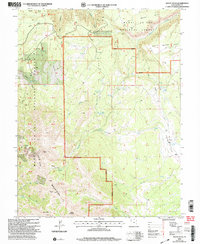
2001 Map of Mount Waas
USGS Topo · Published 2004About this map
The high-altitude peaks of the La Sal Mountains dominate this landscape, culminating in the prominent summit of Mount Waas and nearby Manns Peak. This survey, revised by the USDA Forest Service in the early 2000s, details the high drainage basins and alpine terrain within the Manti - La Sal National Forest. Evidence of historical land use appears in the narrow 4WD tracks that navigate the steep grades toward Burro Pass and the isolated Beaver Basin.
Find a feature on this map
75 named features on this map. Tap any name to fly to it.
Don’t see what you’re looking for? This feature index may not catch every label — zoom into the map to look around manually.
Map Details
Editions of this 2001 Mount Waas Map
This is the sole edition of this map. No revisions or reprints were ever made.
Other maps of this area

1885 · La Sal
USGS Topo · 1:250,000

1954 · Mt Peale 1 NE
USGS Topo · 1:24,000

1954 · Mt. Waas 4 SE
USGS Topo · 1:24,000

1954 · Mt. Waas 4 SW
USGS Topo · 1:24,000

1954 · Mt. Waas 4 NE
USGS Topo · 1:24,000

1954 · Mt. Waas 4 NW
USGS Topo · 1:24,000

1954 · Mt Peale 1 NW
USGS Topo · 1:24,000

1954 · Mt. Waas 3 NE
USGS Topo · 1:24,000

1954 · Mt. Waas 3 SE
USGS Topo · 1:24,000

1954 · Mt Peale 2 NE
USGS Topo · 1:24,000