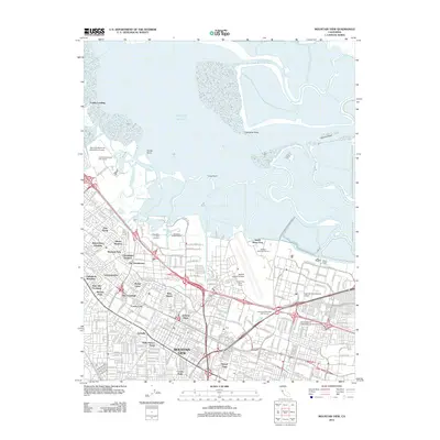
2012 Map of Mountain View
USGS Topo · Published 2012About this map
The dense residential and industrial core of Mountain View meets the southern reaches of the San Francisco Bay in this 2012 survey. Large-scale infrastructure dominates the coastline, from the expansive Moffett Federal Airfield and its specialized Unitary Plan Wind Tunnel to the Palo Alto Airport of Santa Clara County. These facilities sit alongside extensive wetlands and sloughs, including Mowry Slough and Guadalupe Slough, showing the intersection of heavy aviation and maritime history. Inland, the map documents established neighborhoods like Saint Francis Acres, Castro City, and Rex Manor. The area's shift into a major technological and educational hub is marked by institutions such as Cogswell Polytechnical College and International Technological University, while the Caltrain line provides a critical transit spine through the urban landscape. Cultural and recreational sites like the Shoreline Amphitheatre and Shoreline Golf Course occupy the reclaimed coastal edges near Cooley Landing.
Find a feature on this map
193 named features on this map. Tap any name to fly to it.
Don’t see what you’re looking for? This feature index may not catch every label — zoom into the map to look around manually.
Map Details
Editions of this 2012 Mountain View Map
This is the sole edition of this map. No revisions or reprints were ever made.
Other maps of this area

1889 · San Jose
USGS Topo · 1:62,500

1897 · San Jose
USGS Topo · 1:62,500

1897 · Palo Alto
USGS Topo · 1:62,500

1899 · San Jose
USGS Topo · 1:62,500

1899 · Palo Alto
USGS Topo · 1:62,500

1899 · Haywards
USGS Topo · 1:62,500

1902 · Santa Cruz
USGS Topo · 1:125,000

1906 · Pleasanton
USGS Topo · 1:62,500

1915 · Haywards
USGS Topo · 1:62,500

1941 · Pleasanton
USGS Topo · 1:62,500